

Today’s Cartography Puzzler: What is the story with the whales who apparently travel across large stretches of land?
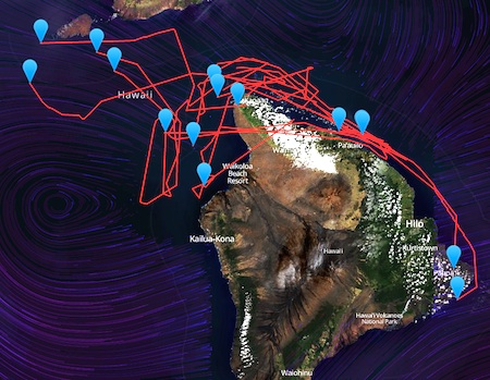
Specifically, what is the story of the lines that cross land areas in this typical image, below, from the Smartmine Whale Tracker?
The whale tracker provides maps showing the location of many tagged whales. At the moment, those whales are all in or near the Hawaiian islands. Each blue upside-down-teardrop represents the current location of an individual whale. As you can see, a few of the red lines — which show the paths recently traveled by individual whales — cross directly over land areas.

Calibration, registration, and how many other -ions enter into the story of the paths that seem to show individual whales swimming, walking, flying or tunneling across, over, through, or under land areas?
The Huffington Post wrote a report about the whale tracker.
BONUS: See if you can determine whether the tracker is doing live tracking, or using a pre-loaded set of data. [HINT: Re-load the tracker page several times, and each time pay attention to the initial locations and movements of the whales.)
BONUS: For background on how the technology of maps, mapping and navigation evolved, take a wander across, over, or through Hiawatha Bray’s new book You Are Here: From the Compass to GPS, the History and Future of How We Find Ourselves.